Mapping Honor: How LiDAR and GPR Strengthen Battlefield Site Documentation
Battlefield sites hold stories that technology alone cannot tell—until now. LiDAR and ground penetrating radar bring new clarity, allowing veteran-led teams to document these places with care and precision. Through UAV photogrammetry and historical mapping, we equip veterans to honor history while supporting families still waiting for answers. This mission goes beyond data; it’s about respect, purpose, and keeping America’s sacred promise. For more information, you can refer to this study.
LiDAR and GPR in Battlefield Documentation
In pursuit of documenting battlefields, LiDAR and GPR are invaluable. They allow us to explore history without disturbing the ground. But how do these technologies work their magic?
Enhancing Precision with LiDAR
LiDAR stands for Light Detection and Ranging, a method that paints a picture of the surface below with fine laser beams. It’s similar to how a bat uses sound to “see” the world. By flying drones equipped with LiDAR over potential sites, we capture detailed terrain models. This process unveils features hidden beneath foliage or debris, revealing landscapes as they once were. For instance, these models can show subtle shifts in terrain, indicating historical trenches or pathways. LiDAR’s precision is remarkable, often detecting minute changes that standard surveys might miss. Each scan layer becomes a page of history, waiting to be read. Explore more on LiDAR’s impact here.
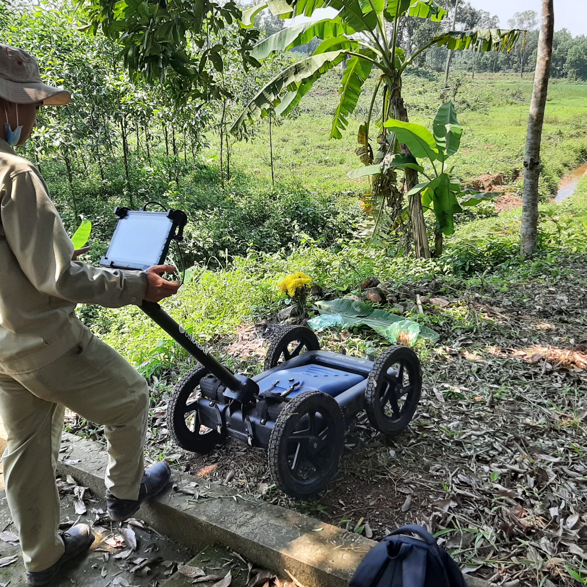
Ground-Penetrating Radar Insights
GPR, or ground-penetrating radar, offers a glimpse beneath the earth’s surface without a single shovel blade. How does it work? This technology sends radio waves into the ground. When these waves hit an object or a different material, they bounce back, creating a map of what lies below. GPR can identify hidden features like foundations or buried artifacts. Imagine scanning a field and suddenly seeing the outline of a historic encampment. It’s like discovering a buried treasure map, each signal marking a place of potential significance. Discover the science behind GPR.
Veteran Training and Mission Purpose
Armed with cutting-edge tools, our veteran teams are trained to chart history while supporting families. Their mission is steeped in honor and precision.
Veteran Training Pipeline
Veterans bring a unique skill set to this mission. However, transitioning from military to tech-savvy historian requires training. Our training pipeline equips veterans with skills in UAV operations, photogrammetry, and GIS mapping. They learn to operate drones, interpret LiDAR data, and conduct archival research. This blend of technology and tradition ensures they can handle the complexities of field missions. Courses are hands-on, with real-world applications, preparing them for the challenges of documenting battlefields. This training provides veterans with renewed purpose, turning past experiences into future opportunities. A detailed report on veteran training is available for those interested.
Family-Centered Mission Approach
At the heart of our mission are the families still waiting for closure. Each veteran-led mission prioritizes their stories and hopes. We engage with families, learning about the missing loved ones. Their stories guide our research and documentation efforts. This approach ensures that our missions are more than just technical exercises; they are acts of remembrance and respect. Families become part of the mission, their narratives woven into our findings. This partnership transforms our work from data collection to a heartfelt tribute. Learn more about our family-centered approach.
Supporting Tours of Duty’s Mission

Our mission is about empowerment and partnership. Here’s how you can get involved and make a difference.
Empowering Veteran-Led Missions
Veterans leading these missions are not just operators; they are stewards of history. Their work supports our nation’s promise—no one left behind. By employing advanced technologies, they ensure each mission is precise and respectful. These efforts preserve history and support those waiting for answers. It’s an act of national honor and personal dedication. By investing in their skills and futures, we ensure the mission’s success and sustainability.
How You Can Support the Cause
Every effort requires support. Whether through donations, partnerships, or spreading the word, you can make an impact. Supporting these missions means honoring our missing heroes and empowering veterans. Your involvement boosts training, enhances technology, and strengthens our resolve. Without you, the story remains incomplete. Join us in our commitment to remembrance and service. The longer you wait, the more stories remain untold. Together, we can ensure that no hero is ever forgotten.
In conclusion, the use of LiDAR and GPR in battlefield documentation is more than just a technological advancement. It’s a promise kept to our veterans and their families, a pledge that their stories will be preserved and honored. Let’s continue this mission with dedication and resolve.
Donate Today: https://fnd.us/TODCambodia?ref=sh_4CkiMc